The Lariam Tab Route

With an average of 20 miles per day, our route gracefully weaves through scenic villages, historic landmarks, our industrial heritage and moments of remembrance.
Total Distance: Approximately 420 miles.
Duration: 22 days.
Route: From West Linton (Scottish Borders) to Whitehall (London)
Highlights: The Scottish Borders ancient drovers’ paths, hidden railway trails, Hadrian’s Wall, historic battle sites such as Towton and Naseby, Sherwood Forest, the Grand Union Canal and London’s Royal Parks. Most important, it will pass a number of commemorative sites, ending at the Cenotaph in London.
Route Overview

The start is West Linton in the Scottish Borders, south west of Edinburgh, where former army major Cameron Quinn became a Lariam suicide. Heading south east to Hawick, the Tab crosses into England at Kielder Water. Through remote Northumberland and over Hadrian’s Wall at Hexham, the path takes us to County Durham, past Coundon – the site of another Lariam suicide (Chris Small). Passing through Darlington, country roads and paths navigate Yorkshire, mainly east of the A1. Former coalmining towns then lead to Sherwood Forest, the Vale of Belvoir, and to Northampton General Hospital, where Major General Alastair Duncan died while sectioned with Lariam toxicity. Striking south east will allow a call on Roche (UK)’s HQ at Welwyn Garden City. Central London will finally be approached through Potters Bar and Hampstead Heath. The Cenotaph at Whitehall is the final objective after 420 miles.
Day-by-Day Itinerary
Day 1. 29 Aug. West Linton to Innerleithen. 18 Miles. At West Linton we pause to remember Cameron and all military suicides before heading to Damside. Cameron loved the hills so this is a really fitting start. His heroic widow Jane and girls, now in Australia, will be with us in spirit every step of the way. Definitely stout boots and waterproofs in the daysack. At Damside we pick up the ancient Cross Borders Drove Road to Peebles, following in the steps of herdsmen taking their animals to market over the border. Peebles to Innerleithen will be along the Tweed Valley Railway Path via Cardona


Jane and much-loved husband Cameron
Day 2. 30 Aug. Innerleithen to Hawick. 21 Miles. From Innerleithen it’s a short tab to Traquair. More glorious Scottish hills, picking up the Borders Drove Road again, and then the Borders Abbeys Way to Hawick via Broadmeadows, Middlestead and Wollrig. Time to reflect on the steps of ancient travellers on the way but keeping an eye on the map and GPS.

Day 3. 31 Aug. Hawick to Kielder. 22.5 Miles. A couple of miles extra on Day 3 to test resolve. Mostly on minor roads after a pull uphill in the morning to get out of Hawick. Orchard, to Deanbrae and Bonchester Bridge, to the B6357 to Cleuch Head, Saughtree and on to Kielder/Battery Haugh. Probably the most isolated leg of the whole route and, as we approach Kielder, we say thank you and farewell to Scotland.

Crossing the border into England
Mark Rodhouse
Day 4. 1 Sep. Kielder to Wark. 21.25 Miles. Today is an especially big day with our path taking us through the woods past the serene Kielder Water. This remains a special place for Sharon, the widow of former Sgt Mark Rodhouse, who died in 2022.

They were both foresters and new this place well. On to Charlton via Hawkhope, Falstone and Lanehead. We’ll follow the River Tyne Trail to Bellingham and then it’s the B6320 down to Wark. We’ve crossed the Pennine Way and will draw inspiration from other hiking soulmates (or maybe solemates). Today Sharon will be in Tasmania but plans to be walking with us. A wonderful thought.

Day 5. 2 Sep. Wark to Riding Mill. 17.5 Miles. From the map this looks like it’s going to need some careful navigation. As a soldier and archaeologist, I’m looking forward to this leg. From Wark to Barrasford, Chollerton, and West Cocklaw we get to Heaven Fields Battle Site (633). I knew nothing of this battle before the Tab and plan to return to explore properly. We cross Hadrian’s Wall at Mould’s Close. Acomb, Oakwood, Corbridge and Corbridge Station, and on to the A695 to Riding Mill. (Depending on aches/blisters, it might be nice to avoid the A695 and pick up the River Tyne Trail again.)
Day 6. 3 Sep. Riding Mill to Crook. 22 Miles. Our road from Riding Mill continues along the Tyne Trail but as we climb, we leave it behind and pick up the line of the Roman Road, Dere Street, and pass the old fort at Ebchester. Roman and rural will transition during the day to coalmining heritage. The Deerness Valley Railway Path should mean easy navigation later, providing relief from traffic and delivering us neatly to Crook.
Day 7. 4 Sep. Crook to Darlington. 18.75 Miles. An important stage. Today goes through the heart of the historic Land of the Prince Bishops. We get hints of Durham Cathedral and Saint Cuthbert, and after Howden-Le Wear the road passes the Prince Bishops’s Palace in Bishop Auckland. Now we drop down towards Coundon, reflecting on the key purpose and remember another Lariam suicide, Chris Small who died there.

Here, in spirit, widow Mandy and son Jamie join Jane and the girls for the rest of the Tab. After Shildon, its Heighington, Cross Lanes, Walworth Gate, Archdeacon Newton, Darlington. We have also just passed the home of yet another young victim of Lariam, still alive but terribly damaged.

South Cowton Castle
Day 8. 5 Sep. Darlington to South Otterington. 21.25 Miles. At Blackwell Grange Golf Club, we pick up the glades of the Teesdale Way to Croft-on-Tees, the childhood home of Lewis Carroll. Did Alice take Victorian Lariam? A few miles of the A167 to endure but at Dalton-on-Tees the westerly B1263 bends south through the Vale of Mowbray. The A1 (Dere Street) is to the right and the Great North Coaching Road over to the left. Small villages and deserted medieval settlements like South Cowton, lead to Yafforth, bypassing Northallerton towards Newby Wiske and South Otterington.
Day 9. 6 Sep. South Otterington to Boroughbridge. 17 Miles. Today we have the Pennines to the right and the North York Moors to the left, with the White Horse on Sutton Bank for company. The lower Swale valley offers a route from South Otterington to Skipton-on-Swale, Topcliffe, Cundall, Thornton Manor and Boroughbridge, crossing the larger River Ure at the day’s end.
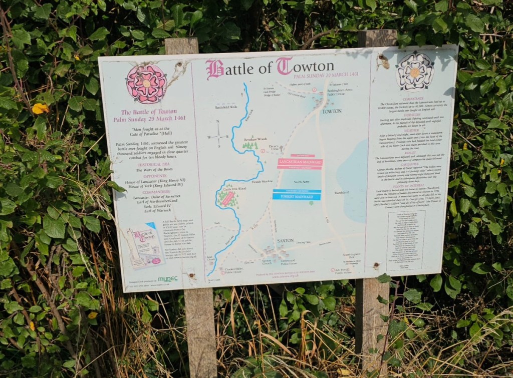
Day 10. 7 Sep. Boroughbridge to Towton. 20 Miles. From Boroughbridge it’s the Roman Dere Street (B 6265) south towards Whixley. It’s a B road yet busy so maybe a day for a high vis jacket. But it’s straight. Then over the A59 to Cattal Station, where they apparently still operate manual gates at the level crossing. Then the brewing and market town of Tadcaster (via Walton (East) and Wighill) and over the River Ure. We head out of town on the A 162 to Towton.
Day 11. 8 Sep. Towton to Little Smeaton. 19.5 Miles. Continuing on the A162 towards Sherburn in Elmet, the open fields on the high ground to the west host the site of England’s bloodiest battle, the Wars of the Roses clash at Towton in 1461.
Through South Milford, Monk Fryston, Hillam, Birkin, and over the Aire at Beal and then the Aire and Calder Navigation and the M62.

Low, flat terrain with hints of past industrialisation towards Cridling Stubbs, Womersley and the charming villages of Kirk and Little Smeaton.

Day 12. 9 Sep. Little Smeaton to Maltby. 20.5 Miles. Minor country roads from Little Smeaton head to Campsall, Carcroft and Adwick Le Street. Crossing the A1 to Pickburn and Marr. At Marr Hall Farm on A365 we pick up the bridleway, heading south east to Sprotborough where we cross the River Don.

A few miles east is Doncaster, and a salute to Captain Gary Case who committed suicide there in 2019. Next a sharp switchback through Levitthagg Wood and on to Warmsworth, through residential areas to pick up the B6376 to New and Old Edlington. At White Cross it’s due south on Long Leys Lane, over the M18 to Braithwell and hence to Maltby.

Day 13. 10 Sep. Maltby to Edwinstowe. 19.5 Miles. Leaving Maltby on the A634, we pick up the footpath at the War Memorial and drop down through Nor Wood and then on to the ruins of the Cistercian Roche Abbey. Interesting to contemplate the fate of an earlier Roche. Soon we find paths heading towards Firbeck, and then pass between Woodsetts and Carlton-in-Lindrick, and so down into Worksop. The B6034 leads to Budy, Sherwood Forest and, approaching Edwinstowe, the Major Oak, named after the antiquarian Major Hayman Rooke. As a soldier and archaeologist myself, I’m delighted to encounter this venerable witness to history.
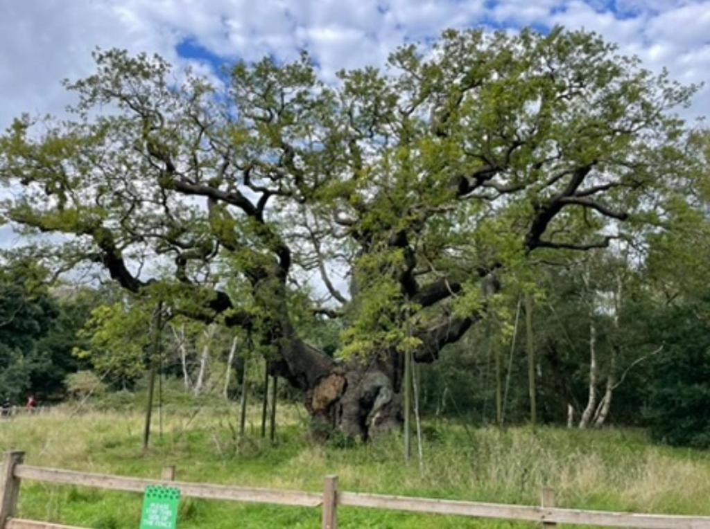
The Major Oak – Estimated to be 800-1100 years old
Day 14. 11 Sep. Edwinstowe to Bingham. 20.5 Miles. From Edwinstowe we take the B6034 to Rufford Country Park and pick up May Lodge Drive. A track then passes Park Lodge and Rufford Stud Farm. Bypassing east of Bilsthorpe on Eakring Road, the Forest Link at the south of the town accesses the Southwell Trail as far as Farnsfield. Combs Lane and Combs Wood bring us to Greaves Lane, near Rough Wood. Now we follow a ridge over Loath and Robin Hood Hills and Windmill Hill into Oxton. Taking Sandy Lane eastwards, we meet the Southwell Road and head south to the track to Park Farm and continue cross-country to Epperstone. Gonalston Lane gets us to Lowdham, via Lowdham Mill. Unfortunately, Gunthorpe, with the bridge over the Rivier Trent, and Bingham force us onto the A6097 but mercifully there is a pavement most of the way.
Day 15. 12 Sep. Bingham to Barsby (SW of Melton Mowbray). 21.25 Miles. Yesterday took us over the Roman Fosse Way (now the A46). Paralleling Rome’s Legions through fine countryside, it’s mainly a due south tramp through Tithby, Colston Bassett, cross-country to Kinoulton, and over the Grantham Canal at Hickling. We approach the Leicestershire Wolds at Nether Broughton, down to Saxelbye and over the River Wreake at Asfordby. From Kirby Bellars and just short of Gaddesby, a short cut on the Midshires Way accesses Mill Farm, hopefully with windmill according to the map, and a short walk into Barsby.
Day 16. 13 Sep. Barsby to Lubenham (W of Market Harborough). 18 Miles. Perhaps sustained by a pie from nearby Melton Mowbray, we head to Baggrave Hall and Baggrave deserted medieval village. SE to another deserted village at Cold Newton and up Sludge Hall Hill to the B6047 and on to Three Gates. SW to Kibworth Harcourt, over the A6 to Smeeton Westerby and Gumley. Perhaps a small diversion to Foxton Locks, Britain’s longest staircase flight of canal locks, and a welcome pint of real ale in the pub before Lubenham.
Day 17. 14 Sep. Lubenham to Boughton Stn (Northampton). 17.5 Miles. Out of Lubenham on the A4304 and shortly pick up the minor road to Marston Trussell and Sibbertoft. After a few twists out of Sibbertoft, a long, straight country road takes us past another major battlefield, Naseby 1645, a decisive victory for the New Model Army over the Royalists. A bridge helpfully navigates the A14 to Naseby village. The minor SE road out of Naseby leads to Vale Farm, from where we need to work our way through Cottesbrooke, and on to the Brampton Valley Way just south of Glebe Farm. The Brampton Valley Way takes us to Boughton Station on the northern outskirts of Northampton.
Day 18. 15 Sep. Boughton Stn to Olney. 16.5 Miles. Another key day as the road goes through Northampton towards Northampton General Hospital, where Major General Alastair Duncan died after Lariam-induced psychiatric incarceration. Crossing the River Nene, we pass Delapre Abbey and the site of the Wars of the Roses 1459 Battle of Northampton. Not as bloody as Towton which we passed a week ago but apparently the first battle where artillery was used in England. Passing under the A45 accesses Hardingstone and Wootton and the B526 to Horton. From Horton, the Northamptonshire Round leads to Manor Farm and cross-country paths to Weston Underwood. Olney lies a mile or so on the minor road heading east.
Day 19. 16 Sep. Olney to Sharpenhoe (N of Luton). 21 Miles. There are multiple public footpath options but the simplest for navigation and avoiding risks of diversions is to take the Ouse Valley Way, crossing the Ouse over two footbridges and making for Clifton Raynes. A combination of roads and bridleways meet the Milton Keynes Boundary Walk at Gorwelle heading to Astwood. Now minor roads lead southwards without difficulty to Cranfield. About a mile east of Cranfield at The Sugar Loaf we drop down to Marston Moretaine, and after Millbrook Station flank the east of the Vehicle Testing Ground and make for Flitwick. Thence on to Westoning and the John Bunyan Trail to get underneath the railway. Now we head almost due east to Samshill Farm and Upper Samshill Farm, dropping down to Mill Farm and along Harlington Road to Sharpenhoe. Practically invisible in today’s landscape, we’ve just crossed from King Alfred the Great’s Wessex into the land of the Viking Guthrum.
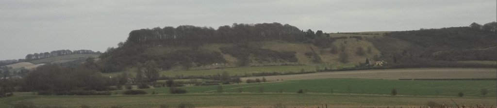
Sharpenhoe Clappers: King Alfred’s view of a Viking Kingdom
Day 20. 17 Sep. Sharpenhoe to Welwyn Garden City, Roche HQ. 19 Miles. Morning is probably a good time to pass the reputedly haunted Sharpenhoe Clappers and the Iron Age Fort. Keeping them to our left, we make for Streately, then east on Barton Hill Road. Short of Barton Hill Farm, we drop south on the Chiltern Way/John Bunyan Trail and cross the ancient Icknield Way and follow the track below Wards Wood and on to Lilley. We are right in the Chiltern Hills now and follow Lilley Bottom Road to Whitwell, and thence to Codicote, and the B656 to Welwyn. From Welwyn we need the B197 and Digswell Hill to cross over the A1. Enter Sherrards Park Woods and make for Pentley Park/Temple Wood estate. Use Lyles Lane to cross the railway and follow to Roche HQ, in Falcon Way. I wonder if anyone there would like to talk about Chris Small?


Day 21. 18 Sep. Welwyn Garden City to High Barnet Stn, London. 13.5 Miles. From Falcon Way we pick up Bessemer Road and Broadwater Road and the A6129, passing the Premier Inn to Herts Police HQ. We can now go through Stanborough Park and pick up Woodhall Landing Lane and Mill Green Lane to the A1000 and the Hertford Road. If it’s open we, can go through Hatfield Park; otherwise, we stay on the road around its western boundary. We will join the Great North Road (still A1000), heading south with Hatfield Station on the right. We keep on the pavement to Brookman’s Park and Potters Bar. In Potters Bar the A1000 becomes Barnet Road. Now very suburban, we keep on, under the M25 to Monken Hadley and eventually to High Barnet Station.
Day 22. 19 Sep. High Barnet Stn to Whitehall. 12.5 Miles (or a bit more). Today it could be more A to Z than Ordnance Survey but we’ll try something different and a final challenge trying to keep off high streets as much as possible. At Barnet we’ll locate one of the capital’s green routes. The Dollis Valley Green Walk will take us through some open spaces and riversides, delivering us to Hampstead Heath, North End. If that works, it’s through the Heath to the B511 and South Hampstead. We have to do some streets now, so it’s the A41 to St John’s Wood, past Lord’s Cricket Ground and then the B507 to Marylebone. From there we can push on fairly easily to Marble Arch and the Royal Parks. Into Hyde Park, Green Park and St James’s. Brace up for a smart gait across Horse Guards and into Whitehall.

Journey’s End
